
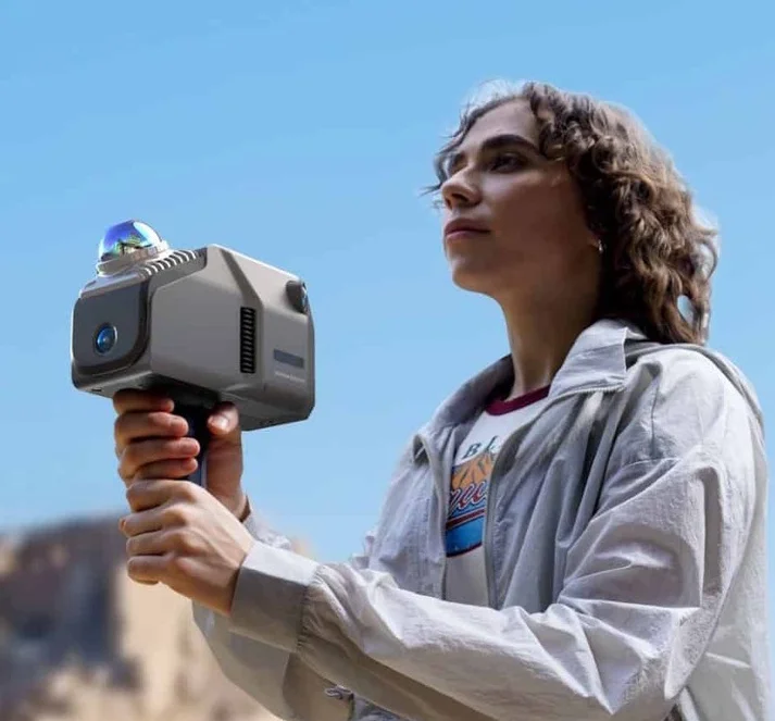
Scanner SLAM Eagle
Walk. Scan. Done.
Backpack SLAM scanner for large-scale 3D surveys, built for fast mobile acquisition with integrated RTK georeferencing.
The SLAM Scanner for Large-Scale 3D Surveys
Eagle is a cutting-edge mobile scanner that enables real-time 3D scanning and mapping without external reference points. Ideal for topographic, construction, archaeological, and industrial surveys, indoors and outdoors, even while moving at up to 20 km/h.
Maintaining data quality even at 20 km/h
Accurate measurements up to 140 metres away
Fisheye optical system for wide-coverage imaging
Vibrant colours and wide dynamic range
Built for Every Environment
Wide-Range High-Precision Scanning
Models entire urban areas, parks, facilities or historic buildings as you walk. One of the few scanners capable of working at up to 20 km/h.
Ultra-Wide Field of View
360° × 59° coverage, the ideal tool for complete 3D surveys even in complex environments with no blind spots.
High-Definition Imagery
48 MP and 8K HDR images for photorealistic digital reconstructions, essential for conservation surveys and interior architecture.
On-Site Instant Review
View the point cloud directly on the 3.5" screen with instant visual feedback: avoid mistakes and duplication in the field.
RTK Centimetric Accuracy
Integrated L1/L2 RTK module enables centimetric accuracy with a base station connection, accurate point clouds even while moving.
Mobile Acquisition
Captures up to 200,000 points per second: walk corridors, tunnels, streets or large facilities and capture everything in a single pass.
From Raw Scan to Deliverable
Eagle comes with dedicated processing software for point cloud editing, cleaning and export. Combined with Analist 2027, it becomes a complete survey-to-BIM pipeline.
Advanced Data Processing
Edit and refine point cloud data with output in PLY, PNG+OBJ and Gaussian Splatting PLY formats.
One-Click Point Cloud Cleaning
Automatic noise removal to streamline the entire workflow, faster operations, cleaner deliverables.
Analist 2027 Integration
Import Eagle point clouds into Analist 2027 to generate terrain models, extract sections and elevations, calculate volumes and create BIM-ready drawings.
From Field to Deliverable, In Three Steps
Walk the site at up to 20 km/h. Eagle captures 200,000 points per second with simultaneous 48 MP and 8K HDR imaging.
Clean and refine the point cloud with one click. Export to PLY, OBJ or Gaussian Splatting, or import directly into Analist 2027.
Generate terrain models, extract architectural sections, calculate volumes and export DWG, IFC or digital twin outputs.
Choose Your Configuration
Eagle Standard
The compact and versatile solution for precise surveys.
- 1 camera · 48 MP fisheye
- Full field of view: 360° × 59°
- Ideal for indoor environments and architecture
Eagle Max
Maximum performance for the most advanced projects.
- 4 cameras · 48 MP for ultra-realistic textures
- 8K HDR images with vibrant colours and exceptional depth
- Wider field of view for superior coverage
Frequently Asked Questions
Technical Specifications
Ready to Map at Scale?
Eagle turns walking into surveying. Request a demo or get in touch with our team.
Request Info